After the Ob valley we first follow the river Kunovat which has one of the most dynamic channels. The flow of the water consumes the outer bank of the river bend until the widening loop meets another loop and the flow short circuits. This leaves the old river channel between the connecting points redundant. It will disconnect from one or both ends forming an oxbow lake.
Another screenshot of Google Maps reveals the incredible history of river Kunovat. We see oxbows which seem to have born within the last century and those which may be many hundreds of years old.
This is pretty much all we see for about 300 kilometers. The terrain is virtually roadless and the only signs of human influence are the occasional gas and oil pipelines conducting those valuable natural resources to processing or shipping locations. Here and there are also small towns built along these lines for the construction and operation of the pipelines. Especially natural gas need enough pressure to move efficiently and the compressor facilities are huge.
The natural gas processing and compressing facility in Long-Yugan virtually in the middle of nowhere. About two thousand people live here all year round.
For an average city dweller the Siberian forests are full of strange landscapes and even more impressive signs of human activity, oil drilling facilities and so on. The old Finnish saying "Siberia will teach you" suits the occasion in more ways than one, although the origin is more sinister. Under the Russian rule between the years 1809 and 1917 the Finnish citizens faced similar legal actions as Russians. One very much feared type was the deportation to Siberia. This was especially used for dissidents, whose influence to other people could easily be cut off totally by a long exile in the new Russian Far East settlements.
This time it is our turn to enjoy the truly educational aspects of traveling in Siberia. The next cluster of Panoramio icons pops up near the town of Tarko-Sale. This means that Tarko-Sale is both important as home town but also for tourists and maybe business travelers. Not surprisingly the existence of the town owes to the nearby oil fields. The headquarters of the largest private Russian gas company Novatek are in Tarko-Sale.
The town seems to be very wealthy. Its architecture, shops and warehouses are modern and the city is very clean. As a contrast to the modern cityscape the nomadic traditions of this area are also on display. The image below (by oldsmog) shows the annual reindeer herder's day festivities on the river ice.
The tepee like chums look exactly similar as those of the Lapps in the Nordic countries. The leftmost has traditional reindeer skin covered walls. The festivities include reindeer racing which here is done on sleighs, whereas in Finland usually no sleigh is used, rather than the driver is on skis.
Another lesson of Siberia is how to keep up with speed here. So we go on eastwards following briefly the flow of River Chaselka which crosses the marshy landscape. There are countless lakes, many of which are close to perfect circle shape. Soon we cross the border to the Krasnoyarsk region.
For a long time we have seen no Panoramio icons on the map. Suddenly a great river appears. It is the second and biggest of the Siberian giants, the Yenisei. The location where the 65th parallel crosses the river is about 1080 kilometers from the mouth of the river. Even here the Yenisei is about 3 kilometers wide and especially during the spring flood the discharge of the river nearly equals that of the great Amazon. Unfortunately near our latitude there are no published photographs available, so we go a bit further to find a tributary of Yenisei, the Sukhaya Tunguska.
The Big Rapids of the Sukhaya Tunguska (image by Dimitriy Sakash). Pay attention to the water polished boulders in front of the picture.
The name Tunguska reminds us of one of the great events of the Earth. In 1908 a small asteroid or comet exploded in the air and created much destruction in Siberia. The exact location however is in south-east, about 800 kilometers from here.
After this river the wilderness becomes even more desolate. This does not mean that there would be nothing to see in the nature. The wildlife concentrates on the river valleys which cross the landscape most often from south to north. The terrain is also more variable. Regions of hills come and go, the highest are between 600 and 900 metres. The elevation is an additional stress factor for the trees and in the highlands we can see the first real tundra areas, where no trees grow anymore.
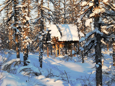
Finally there appears a clutch of Panoramio icons. I pick the first one (photo by Sergey Volkov):
The image title identifies the structure as a labaz. By the looks of it, it could be a bear cache for foodstuffs or alternatively a hunting platform. For the first time I would really want to meet the photographer to find the answer. Not far away from this location comes the river Kochechum. We see people fly fishing there.
This may actually be our photographer, but then we face a dilemma. Obviously it would have been difficult to have taken this picture himself... In any case: thank you Sergey - beautiful photos! With this farewell I will also finish today's blog and start planning for the next leg of my and our voyage.


No comments:
Post a Comment