
The image above (by rbkomar) shows the river Bolshaya Synya and the cliffs of the canyon wall. But somewhere in the east the Ural mountains grow larger and larger. The next river is called Vangyr and it gets its waters from several mountain valleys around the 65th parallel.

In the image above (photo by mikhail vanchenko) the river Vangyr is seen upstream against the Ural mountains. As we get closer to the mountains, a couple of details become apparent: There are no snow peaks visible in these images and many of the peaks are rather sharp. The Ural mountains are old - between 250 and 300 million years. It is surprising that the mountains still exist as many ranges of similar age are today gone for good.
Frankly, personally I had no idea of the age of Ural and therefore thought that this famous mountain range would be similar to the Alps in height. In reality the highest peak, Mount Narodnaya is just 1895 meters high. Still, there are permanent glaciers on the slopes and in the valleys as we are so up north.
When traveling in Google Earth we need not to worry about the terrain below. A gentle nudge on the globe and the ground rotates. The mountain valleys are full of image icons and we want to review all the photos of course. One of the valleys, that of the river Kosyu goes fortunately in east-west direction and there we see the most spectacular images of the most important peaks of Ural.
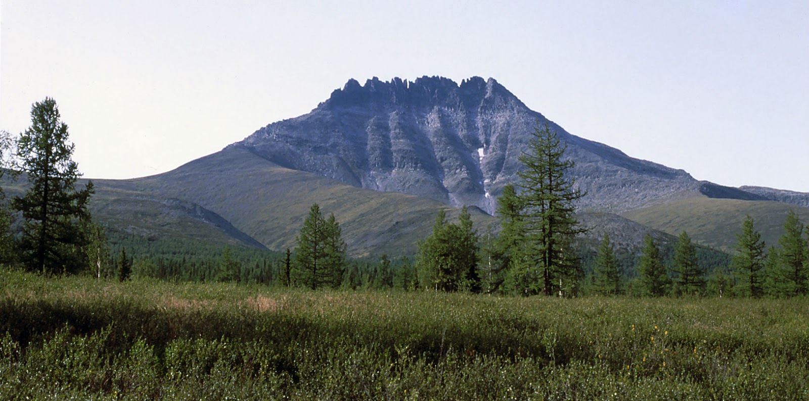
This image (by Szilagyi Lenke) shows the jagged silhouette of Mount Manaraga as seen from south-east. The camera stands almost exactly on the 65th parallel. The mountain itself has almost symmetrical sawtooth profile which comes from the combination of different minerals forming the mountain. Going a bit more to the east there are several high peaks including the two which are even higher than Mt. Maranaga. We already mentioned Mount Narodnaya and almost next to it is the second highest peak, Mount Karpinsky.
The waters from the slopes of Mt. Narodnaya gather together to form brooks and rivers including the river Naroda. This is a totally different body of water since it flows towards east to eventually merge with tributaries of River Ob.
As we all know, Ural mountains form the border between Europe and Asia. Apart from the mountains themselves there are also more formal signs of this frontier.

The pole in the middle of the image above (photo by Aleksandr Dygas) is one of the markers of the Europe-Asia border. The border has been there for ages and it has also been subjected to disputes. However no fights or international conflicts have arisen to defend the border line. Apparently the significance of this border is so low that a single watchdog is sufficient.
After crossing the border to Asia the mountains remain on the European side, so the continental boundary line does not really coincide with any administrative borders of Russia. At the same time the beaten paths are left behind and we enter the treeless highland, which goes on for almost 70 kilometers until suddenly it slopes down to the same type of forest wilderness as seen on the western side of Ural. If possible, the forest may be even more wet.

This is a screenshot from Google Maps. River Lyapin comes from north and just below our latitude the river Engotayu merges with it from east. It is easy to spot the most recent oxbows, but watch closely and you can find numerous, almost invisible ghosts of ancient river bends carved in the soil and moss.
Panoramio users may not cope with the mosquito infested forests, because photo postings are few and far between. So we continue over the northernmost areas of the Khanty-Mansiysk autonomous region and cross the border to Yamalo-Nenetsk autonomous region. Soon we enter the mega delta of the river Ob. There are more and more small rivers below - all flowing to the direction of Ob or its smaller tributaries.

The village of Yamgort by the river Synya is basking in the sunshine (photo by George). It almost looks like the had a sale in the house paint department of the local supermarket. Never have we seen so many houses in such a nice finish in one village.
The Ob valley is wide and wet. The bayous of the Ob cover a width of 30 - 40 kilometers and only small patches of relative dryness in between.

The image above (by George) shows a Nenets settlement on a flat isthmus between two branches of river Ob. Coincidentally this place is very close to the special place on the earth where the 65th latitude crosses the 65th longitude (east). A similar encounter awaits us in the western hemisphere.
It is easy to understand what this landscape looks like during spring time when the snow melts. Spring flooding may explain this sight not far from the previous photo.

The river boat has obviously hit ground during a spring flood (image by George). Several kilometers separate it from the main channels and at the end the boat could not be salvaged.
The river Ob is really huge. It compares well with the Mississippi-Missouri rivers of North America both in total length and flow numbers. Even here the main tributary Irtysh contribute much of the total length. So now we have met the first one of the Asian giants.
No comments:
Post a Comment