Monday, May 23, 2016

Children of the Gold Rush.

The town of Tanana is left behind when we continue our journey more or less following the River Tanana. After a while there appear a great number of photo icons at a location labeled as Manley Hot Springs. On the river bank we see an Alaskan specialty fish trap.

This device (photo by DosKumaks) placed on log pontoons can scoop fish from the stream without any human intervention. Of course there must be suitable fencing in the river to guide the fish to a narrow channel where this monster is waiting for them. A little bit away from the Tanana are the hot springs at Baker Creek. This miniature town has only 89 inhabitants. I can however count 10 small planes parked at the airport!

Further parking space for sea planes is available on the Baker Creek (photo by Jim Keir). Maybe the hot springs really bring tourists in the town. The Elliot Highway brings also people traveling with cars. We will follow the highway to north-east. There comes a turning with a sign to the town of Minto.

Minto is a remarkable town (photo by JKBrooks85) for indigenous Alaska. First, about 92 % of the townspeople are native Americans and secondly, there live the only Lower Tanana speaking natives in the US. The town itself is located among a cluster of lakes, which form from River Tolovana as it flows on the flatland. From Minto we head back to south-east and soon the Panoramio icons burst to the screen.

The Murphy Dome is a round top hill (image by Ansel Siegenthaler), which used to have an early warning radar station. Today there is only one radar dome and the hill top is a popular sightseeing venue (elevation 885 meters). The clear cut strip in the forest is about 15 kilometers long and it may be just a forestry clearing but obviously it has been used for recreational winter sports as well. The Murphy Dome belongs to the Fairbanks North Star Borough. The borough has a population of nearly 100'000 which is already comparable with our starting point, Oulu Finland.

In a city of this size you could spend days in sightseeing. There is certainly much information available, but for my purposes I will pick just few pictures of the Fairbanks Pioneer Park.


This double feature seem to be miles apart from each other. In fact they are both from the Pioneer Park. The steam train (photo by Dirk Lummerzheim) is from the Tanana Valley Rail Road. Now the narrow gauge train runs in the Park. On the right is a magnificently carved bear (photo by Gary Peplow) advertising the Salmon Bake attraction. When in Alaska we cannot dismiss the great winter scenes, although personally I do not enjoy much those cold and dark days.

A masterpiece of ice sculpture is this maze (image by Larry Workman QIN) in the Ice Park of Fairbanks. There is an annual ice sculpting competition, where a similar maze has been an integral part for years.

Outside the city following the River Chena we find an interesting nature trail. The place is called Angel Rocks.

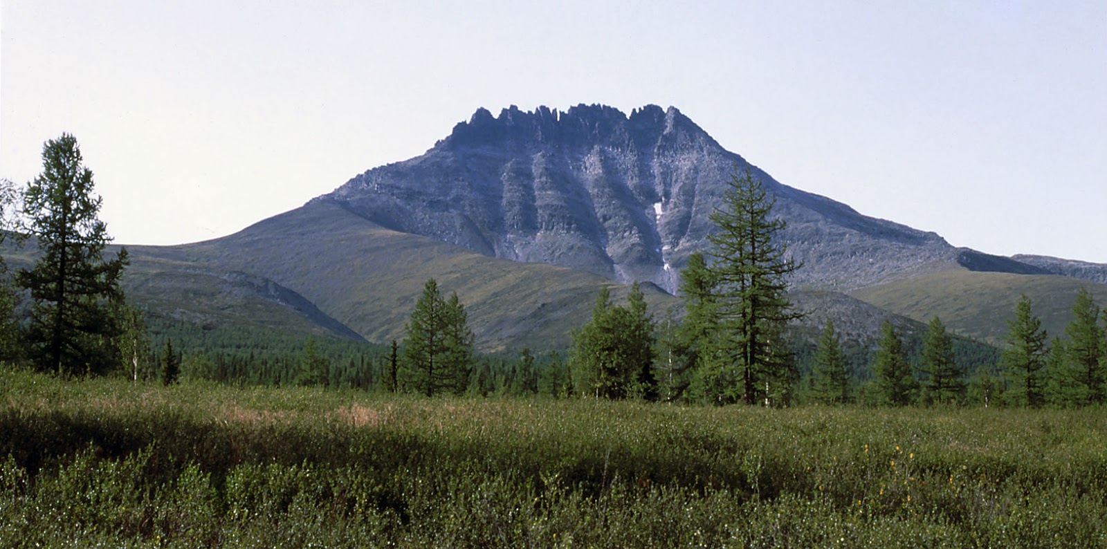
The image above (by watermola) shows the exposed rocks which seem like there has been a volcano eruption just a week ago. The rock face looks like dough oozing from the earth.

We are about to leave the Alaska and the USA when we approach the Canadian border. From the north-west comes the Yukon river back to our view. Yukon is a much used transport route in this landscape where roads are not very common and especially in wintertime often impassable.


I like this picture (by Eli Shorey) very much because of what it tells of the modern Yukon River. Now that even city people have learnt to enjoy the nature and preserve it for us and the generations to come, the feeling in this image is great.

Next we follow the Yukon a short while upstream to the point, where it crosses the 65th parallel again. There is a bunch of photo icons all depicting the same, puzzling phenomenon.


The image of Mt. Windfall (by reisen0815.de) shows a strange looking hill emitting smoke. The event started in September 2012 and there is no data available about what is the current situation, although it was active at least in 2014. Even the scientists could not agree the cause of the smoke, since it was highly improbable that any real volcanic activity would be happening here. What a delicious topic for Discovery Channel this would make: "Aliens mining earth resources!"

Head full with question marks we turn the nose to east and cross the Canadian border.

Saturday, May 21, 2016

Alaska, the most indigenous USA

The Bering strait is very wide at the 65th parallel. Almost 250 kilometers from Russia to Alaskan mainland. However somewhere after midway we encounter land. It is the King Island. Today home only for sea birds it has been home also for a community of inupiat natives.


The Ukivok settlement (image by was finally abandoned in 1970 when all inhabitants were moved to the continent. It is hard to imagine, how tough the life was on the island, when food had to be gathered during the few summer months. The winters were spent more or less inside the four walls.

I checked the ice map of NOAA and found that even now, on last week of May, the King Island is completely surrounded by ice. In a few weeks time there will be visitors coming to the island again. From the top of the island the view to east shows the Alaskan shore if the weather is good. That is where we go next.

The Seward Peninsula on the mainland is geographically very similar to the Russian side. The terrain is low tundra, where small rivers have carved their channels. Little by little the ground level rises and the first mountain come into view. We cross a road and river and see a reminder of the days of the gold rush.


Gold was dug here in industrial scale using dredgers, which operated on the river bank. This unit in the front was probably operating in early twentieth century (image by misterbigtoe). The Kigluaik mountains rise higher and higher and to my delight the Panoramio icons are quite common sight. Since the Kigluaik is not the most spectacular mountain range, I skip the pictures there and find one beautiful spot behind the mountains (photo by R Wideman):


This picturesque landscape is called Pilgrim Hot Springs and it is a ghost village from the Gold Rush era over 100 years ago. It is now designated as a US National Register Historic Place. The church in the center was built after 1918 flu epidemic for the orphanage. The Seward Peninsula is not very crowded place. After 50 kilometers we see a small town near the Niukluk River. The town of Council is quiet as it has not had permanent inhabitants in 100 years. Today it is a history site on summer months, where you can see old mining equipment lying around.


This image (by Christophe Rochat) shows one piece of the historical junk found in the town and in the vicinity. After leaving Council the landscape turns again very mountainous. The inner parts of Seward Peninsula are virtually roadless and even the smallest villages have an airport or actually just a landing strip for small planes.

The landscape is by no means monotonic, but due to the low accessibility those with a camera seem not to frequent these areas. The things change only when we arrive to the neck of the peninsula where the River Koyuk discharges to the Norton Bay and sea. The town with the same name is built on the northern bank of the final bend of the river.

The image ( by Dan Baldini) shows the town of Koyuk seen from south-east. I have the feeling that the sea will not be seen for a very long time. With this view in mind we continue to east. The tundra seems endless but the from south we see a large river. It is the Yukon, which just short of the 65th parallel turns east and starts to follow our latitude. Yes, fair enough, of course the Yukon flows from east to west, but still it remains with us for some distance.

Right after the bend there is another small town with another indigenous name Koyukuk. With only 100 inhabitants it is interesting that the airport is actually better equipped than that of Koyuk.


This image (by Will Forsberg) shows the sandy shores of River Koyukuk, which joins the Yukon right at the town Koyukuk. But back to the Yukon where we see a continous stream of islands in the river, as the Yukon's multiple channels are twisting like a watery braid. This seems to be common for the rivers in the permafrost landscape.

This plaque (image by Pavel Filin) is found on the shore of Edith Island in the Yukon River. The place is called Cross Point. It is too easy to forget those history lessons, but in fact Alaska used to belong to Russian Empire until the year 1867. The signs of the Russian presence can still be found in many places. That is one reason why Alaska is also very popular for the Russian tourists.

Upstream the Yukon channel the river starts to turn more and more north. Just as we are about to leave Yukon for good, we encounter a small town called Tanana. Tanana is also a river which joins the Yukon here.

The city offices of Tanana are in this traditional style log house (photo by Pavel Filin). It is nice to see how, despite its mere 280 inhabitants, complete functioning town Tanana is. The airstrip is 1700 meters long, enabling even mid-size planes to land and take-off. This has some historical significance since during WW II military airplanes exported to Russia made landing in Tanana. About 80 % of Tanana citizens are native Americans.

Wednesday, May 18, 2016

The smell of the Pacific

After having left the radio station Gorkiy we quite soon cross the river Anadyr again. Now it spreads over a vast marsh plain. In the south it makes the final turn to east and flows to the funnel shaped outlet opening to the northernmost part of the Pacific Ocean, called the Bering Sea.

The latitude 65 N cotravels the final kilometers with another river, the Kanchalan. It too has a similar outlet not far from the Anadyr.


This aerial image (by Sergey Krivonosov) shows the mouth of the river Kanchalan. The 65th parallallel crosses invisible the center of the image. It does not become maritime yet, rather than follows the coastline away from the sea. There are not many Panoramio icons but when the first comes, it stops me immediately.


Soviet military jets parked in the middle of the tundra (image by KUZMARO). There is no airfield here - not even any roads. Is this the Soviet equivalent to the Bermuda triangle? I could count at least 8 individual planes. No explanation could be found. Could they have been positioned here for attack practice targets? Definitively they are all destroyed now. Unbelievable!

Just a few tens of kilometers we encounter the last hills on the Anadyr mainland. The appearance reminds me of small volcanoes and on some you can even figure out crater like structures. Since there are no active volcanoes here anymore, these are probably very ancient. A small creek flows from the hills and the next photo (by tells us that salmon season is almost finished.


After spawning most of the salmon die and the carcasses are scattered on the river banks by eagles, gulls and mammals. The salmons are very important for the nitrogen and minerals they supply to the nature. Quickly hereafter the photographic resources run out and our latitude heads out to the sea on the Gulf of Anadyr. A nice coincidence is that we at the same time cross the 180 degrees longitude line and continue on the western hemisphere.

The sea may have drifting ice almost any time of the year, but else there is not much to see. We find dry land pretty soon again and enter the Chukchi Peninsula at about the village of Enmelen (photo by Ryabinin).


Most of the villagers are fishermen but whaling and seal hunting is also important for the people, which are still mostly of eskimo ancestry. The inner parts of the peninsula consist of low mountains and no images are stored from that area. On the shoreline we find the last images.
 

This graveyard of whales (image by  ) is near the village of Yanrakynnot. The story tells that the whale meat was used for feeding the foxes in the fur farms of 20th century. Actually in this climate the bones are preserved for ages, so they may have accumulated over tens of years.

Before we embark to cross the Bering strait, I must present one final image of the village of Yanrakynnot (photo by nordvoda).


The village proper is far in the background, but the main subject are the parallel bars which could not better suit to finish the Asian part of my journey on the 65th parallel north.

Stories of Soviet Far East

We are in the middle of the Chersky mountain range and start again to move east. The gold miner village of  Predporozhnyi is left behind. I read from a Russian web page that the mountains are tectonically very active since we are in a contact zone of the Eurasian and North American continental plates. There have been many earthquakes in the region and there was even a fairly recent volcano event here - about 240 years ago.

Finland, where I live in, is in contrast tectonically one of the most stable areas in the world. However not many weeks ago I felt an unusually strong tremor at home. This, magnitude 4,2 quake took place in the sea between Sweden and Finland and was one of the strongest tremors ever recorded in Finland. But back to Siberia.


In the above image (by Gérard Guerrier) a group of local herdsmen have camped near a mountain lake. Their animals are of course reindeer, which have no fixed pastures, rather than they migrate semi-wild according to the seasons and the herdsmen follow them in a nomadic lifestyle.


In this picture the reindeer herd is resting close to the same mountain lake (image by Mike1411). The animals like to rest in wind swept places, where the gnats and mosquitos are not so abundant. Not far away from this place in northern direction are the highest peaks of this range.


The Pobeda (Victory) peak is visible in this image on the right hand side.(photo by Mekheda Alexander). With 3147 meters it is by far the highest mountain around. After we continue the voyage, the peaks on the 65th parallel are seen much lower below and the Moma river plateau opens. During the WW II here was a gulag camp, where political prisoners worked in uranium ore mining. There are still some mountains after this plateau and one image deserves to receive our attention.


Human activity in the images is always fascinating although I categorize myself more as a nature lover. The photo above ( again by Mekheda Alexander) shows a rafting party on the river Rassokh, which originates in the Moma Range mountain valleys and flows to east to join the river Kolyma. Our trail takes a short cut and crosses the river in a point with several photo icons. Someone obviously has been here.


This photo documents a memorial for AM Avramenko who traveled these mountains and river Kolyma in early 20th century (photo by wolfzyr). Judging by the text he might have been a gold prospector - or maybe not. Again too little information about this person can be retrieved - what may have been his achievements here?

Continuing our trip we quite soon cross the border of Magadan oblast. Magadan itself reaches the Pacific ocean in the south-east, but it is not the easternmost point of Russia. The 65th parallel only grazes the northern wilderness of Magadan oblast. First stop is a small village called Glukhariny. This is again a ghost town from the Soviet heydays. Glukhariny was a mining base for prospectors and miners of various mineral resources. Since then the profitability of the ores have turned to negative and after 1992 there were very few people living in the village.

This image, taken in 2012 (by Elena Riakhovska) shows distinct activity in the village area. Temporary dwellings are used instead of refurbishing the old abandoned houses. There must be something very interesting going on. A brief search and I found a photo album of one person who actually works here: Grigory Baraulya.


So this is what it is all about. GOLD, and lots of it. Another mystery solved, and we can go on. There is a stretch of rather uneventful landscape and the we cross the river Omolon, which is also border to the final Far Eastern region of Russia, the Chukotka Autonomous Okrug. There is still some 200 kilometers more until the terrain once again turns mountainous and we stop to check the image icons. It is no wonder that all the travelers want to record the mountain scenes, and there really are albums filled with those. I will pick something different in the village of Chuvanskoye:


From distance this house would seem long since ruined (image by freeactive). In closer inspection we notice the fish drying rack on the roof, shiny padlock on the door and the utility pole behind the house, all telling that someone uses this house either seasonally or permanently. There is even a house number 61, but somehow I believe that the postman does not visit this house very often.

We are now on river Eropol, one of the sources of the river Anadyr which will eventually develop into the greatest waterway in this region. We will not follow the riverbed since the direction changes continually. Our 65th parallel leads us to tundra interrupted by small hill regions. On one such we see large structures.

There four panels form the antennas of the tropospheric radio relay station "Gorkiy". It used to be very important part in transmitting communication data between the different parts of Soviet Union. Now in the satellite era its significance is not so big, but due to its immunity to jamming measures it still bears some strategic importance.

There are relay stations like this every 100 -200 kilometers, and this particular station has some extra notoriety on its CV. In summer 1975 allegedly three members of the personnel started to shoot at their fellows and officers and finally flew from the premises. Around 10 persons were killed in this incident.

It seems that the stories have slowed me down again and I need to leave the final part of the 65th parallel in Asia to my next blog issue.

Monday, May 16, 2016

The Yakutian treasures

We managed to cross 36 degrees of longitude in my previous blog entry. That feat was not especially difficult since the only people we encountered during the last part of that blog were adventure travelers of Volkov Travel. Photographic evidence of human visits was else practically nil.

Fortunately we managed to catch some of the lost time back, although by now it is almost sure that my original estimate of 24 blog entries will still not be enough. Well back on the track we go and head deeper into the Central Siberian forests. Apart from few images by Sergey Volkov the Panoramio yields nothing and soon we have the border of the Republic of Sakha below us.

Under the Soviet era Sakha was known as Yakutia. Its surface area is slightly less than that of India but Sakha has less than a million inhabitants. The republic has three time zones.


The image above (by Ruslan Ahmetsafin) shows the forest tundra by a unnamed river. The permafrost layer a few feet below the surface prevents the tree roots to get a stable grip of the soil. Consequently the trees don't grow tall and during the winter the entire tree is frozen solid delaying the spring growth start.


The screenshot of Google Map page reveals the effects of the permafrost to the ground (click to enlarge). The surface contours are brought up like growth rings, when subsurface water freezes and thaws. The freezing expansion creates minute furrows in the peat surface, which in turn enhances the growth of certain mosses and lichens with typical color differences. River Morkoka is seen in the image.


This old track vehicle (image by Alexandr Vermenitsh) was brought to the wilderness maybe to act as a hunter's camping site. Or it just may have broken down there and never completed the journey back to civilization. I have not been able to identify the type, but it certainly looks like a military transport vehicle.

A short way to east the Morkoka merges with River Markha going south. Quite near the junction a deep hole is visible in the ground. We have found a treasure!


This aerial photograph (by skypointer) shows an open-pit diamond mine which is not listed in Wikipedia. The top diameter of the pit is about 500 meters and  judged by the maintenance of the roads it is an operational mine.

The Sakha republic produces about 99 % of all Russian diamonds and it is estimated that about half of the world's known diamond reserves are here. From this distance we have no possibility to spot even a single diamond, so let us continue.

We cross the river Tyung and shortly thereafter the creek Dippa. Next is another proper river called Linde and its smaller sister Delinde. The terrain starts to descend little by little and the last giant river emerges from the horizon.

The Lena is again very much like the first of the large rivers, the Ob. A tangled network of larger and smaller channels covering a width of 15 to 25 kilometers. Although not as long as Yenisei, in the spring it carries more water than Yenisei and might rival even the mighty Amazon. It truly is an impressive sight and we are still almost 1200 kilometers from the mouth of Lena.

The flow is pretty slow since the river is deep and its level slopes only about two centimeters per kilometer.

A sight from one of the channels of Lena (image by Sergey Polovnikov). A fisherman's boat is tied to a sandbank. Although not seen here, on the eastern side of the river there are mountains in the horizon.

The Verkhoyansk Range is actually more prominent than the Ural mountains. Its highest peak is 2480 meters and the snowy peaks seen in the image below give it the appearance of proper mountains (photo by Danila La).


Compared to the Urals there are far less Panoramio photos available. However farther in east we see more mountains and a good deal of photo icons along them. The mountains belong to the Chersky Range where we find an even higher peak, the Pobeda. Before we reach them, we must stop at the valley of river Indigirka. There is the mining village of Predporozhniy. The village was founded about 60 years ago to develop gold mines in the surrounding mountains.

About 2000 people were once stationed here to work in mining and extraction of gold, but the operation was discontinued in 2007. However all people did not move and today about 200 miners still occupy the village and mine the gold during the summer months. I could not find any information, whether this is a private enterprise or run by a company.


A recent view of the village of Predporozhniy (image by Vasyis). Due to the long transport distances the people grow lots of vegetables and fruit on their balconies. Even though the community is very closed and they treat outsiders with due reservations, this is not a bad place to take a deep breath and plan for our final Russian stage to the Pacific Coast.

Saturday, May 14, 2016

Siberia will teach you!

After the Ob valley we first follow the river Kunovat which has one of the most dynamic channels. The flow of the water consumes the outer bank of the river bend until the widening loop meets another loop and the flow short circuits. This leaves the old river channel between the connecting points redundant. It will disconnect from one or both ends forming an oxbow lake.


Another screenshot of Google Maps reveals the incredible history of river Kunovat. We see oxbows which seem to have born within the last century and those which may be many hundreds of years old.

This is pretty much all we see for about 300 kilometers. The terrain is virtually roadless and the only signs of human influence are the occasional gas and oil pipelines conducting those valuable natural resources to processing or shipping locations. Here and there are also small towns built along these lines for the construction and operation of the pipelines. Especially natural gas need enough pressure to move efficiently and the compressor facilities are huge.


The natural gas processing and compressing facility in Long-Yugan virtually in the middle of nowhere. About two thousand people live here all year round.

For an average city dweller the Siberian forests are full of strange landscapes and even more impressive signs of human activity, oil drilling facilities and so on. The old Finnish saying "Siberia will teach you" suits the occasion in more ways than one, although the origin is more sinister. Under the Russian rule between the years 1809 and 1917 the Finnish citizens faced similar legal actions as Russians. One very much feared type was the deportation to Siberia. This was especially used for dissidents, whose influence to other people could easily be cut off totally by a long exile in the new Russian Far East settlements.

This time it is our turn to enjoy the truly educational aspects of traveling in Siberia. The next cluster of Panoramio icons pops up near the town of Tarko-Sale. This means that Tarko-Sale is both important as home town but also for tourists and maybe business travelers.  Not surprisingly the existence of the town owes to the nearby oil fields. The headquarters of the largest private Russian gas company Novatek are in Tarko-Sale.

The town seems to be very wealthy. Its architecture, shops and warehouses are modern and the city is very clean. As a contrast to the modern cityscape the nomadic traditions of this area are also on display. The image below (by oldsmog) shows the annual reindeer herder's day festivities on the river ice.

The tepee like chums look exactly similar as those of the Lapps in the Nordic countries. The leftmost has traditional reindeer skin covered walls. The festivities include reindeer racing which here is done on sleighs, whereas in Finland usually no sleigh is used, rather than the driver is on skis.

Another lesson of Siberia is how to keep up with speed here. So we go on eastwards following briefly the flow of River Chaselka which crosses the marshy landscape. There are countless lakes, many of which are close to perfect circle shape. Soon we cross the border to the Krasnoyarsk region.

For a long time we have seen no Panoramio icons on the map. Suddenly a great river appears. It is the second and biggest of the Siberian giants, the Yenisei. The location where the 65th parallel crosses the river is about 1080 kilometers from the mouth of the river. Even here the Yenisei is about 3 kilometers wide and especially during the spring flood the discharge of the river nearly equals that of the great Amazon. Unfortunately near our latitude there are no published photographs available, so we go a bit further to find a tributary of Yenisei, the Sukhaya Tunguska.


The Big Rapids of the Sukhaya Tunguska (image by Dimitriy Sakash). Pay attention to the water polished boulders in front of the picture.

The name Tunguska reminds us of one of the great events of the Earth. In 1908 a small asteroid or comet exploded in the air and created much destruction in Siberia. The exact location however is in south-east, about 800 kilometers from here.

After this river the wilderness becomes even more desolate. This does not mean that there would be nothing to see in the nature. The wildlife concentrates on the river valleys which cross the landscape most often from south to north. The terrain is also more variable. Regions of hills come and go, the highest are between 600 and 900 metres. The elevation is an additional stress factor for the trees and in the highlands we can see the first real tundra areas, where no trees grow anymore.

Finally there appears a clutch of Panoramio icons. I pick the first one (photo by Sergey Volkov):


The image title identifies the structure as a labaz. By the looks of it, it could be a bear cache for foodstuffs or alternatively a hunting platform. For the first time I would really want to meet the photographer to find the answer. Not far away from this location comes the river Kochechum. We see people fly fishing there.


This may actually be our photographer, but then we face a dilemma. Obviously it would have been difficult to have taken this picture himself... In any case: thank you Sergey - beautiful photos! With this farewell I will also finish today's blog and start planning for the next leg of my and our voyage.

Thursday, May 12, 2016

Asia - where everything is BIG

When we approach the Ural the mountains come in clear view. In Panoramio the images become much more numerous, as there are many mapped trekking routes in the mountains and they are really popular. Even before the foothills the rivers, which bring waters form the Ural seem to be interesting for paddlers and rafters. The rivers differ from those in taiga forests, because they flow in canyons carved in bedrock for millions of years. The rivers totally lack the oxbows which were so typical earlier on our voyage.


The image above (by rbkomar) shows the river Bolshaya Synya and the cliffs of the canyon wall. But somewhere in the east the Ural mountains grow larger and larger. The next river is called Vangyr and it gets its waters from several mountain valleys around the 65th parallel.


In the image above (photo by mikhail vanchenko) the river Vangyr is seen upstream against the Ural mountains. As we get closer to the mountains, a couple of details become apparent: There are no snow peaks visible in these images and many of the peaks are rather sharp. The Ural mountains are old - between 250 and 300 million years. It is surprising that the mountains still exist as many ranges of similar age are today gone for good.

Frankly, personally I had no idea of the age of Ural and therefore thought that this famous mountain range would be similar to the Alps in height. In reality the highest peak, Mount Narodnaya is just 1895 meters high. Still, there are permanent glaciers on the slopes and in the valleys as we are so up north.

When traveling in Google Earth we need not to worry about the terrain below. A gentle nudge on the globe and the ground rotates. The mountain valleys are full of image icons and we want to review all the photos of course. One of the valleys, that of the river Kosyu goes fortunately in east-west direction and there we see the most spectacular images of the most important peaks of Ural.


This image (by Szilagyi Lenke) shows the jagged silhouette of Mount Manaraga as seen from south-east. The camera stands almost exactly on the 65th parallel. The mountain itself has almost symmetrical sawtooth profile which comes from the combination of different minerals forming the mountain. Going a bit more to the east there are several high peaks including the two which are even higher than Mt. Maranaga. We already mentioned Mount Narodnaya and almost next to it is the second highest peak, Mount Karpinsky.

The waters from the slopes of Mt. Narodnaya gather together to form brooks and rivers including the river Naroda. This is a totally different body of water since it flows towards east to eventually merge with tributaries of River Ob.

As we all know, Ural mountains form the border between Europe and Asia. Apart from the mountains themselves there are also more formal signs of this frontier.

The pole in the middle of the image above (photo by Aleksandr Dygas) is one of the markers of the Europe-Asia border. The border has been there for ages and it has also been subjected to disputes. However no fights or international conflicts have arisen to defend the border line. Apparently the significance of this border is so low that a single watchdog is sufficient.

After crossing the border to Asia the mountains remain on the European side, so the continental boundary line does not really coincide with any administrative borders of Russia. At the same time the beaten paths are left behind and we enter the treeless highland, which goes on for almost 70 kilometers until suddenly it slopes down to the same type of forest wilderness as seen on the western side of Ural. If possible, the forest may be even more wet.


This is a screenshot from Google Maps. River Lyapin comes from north and just below our latitude the river Engotayu merges with it from east. It is easy to spot the most recent oxbows, but watch closely and you can find numerous, almost invisible ghosts of ancient river bends carved in the soil and moss.

Panoramio users may not cope with the mosquito infested forests, because photo postings are few and far between. So we continue over the northernmost areas of the Khanty-Mansiysk autonomous region and cross the border to Yamalo-Nenetsk autonomous region. Soon we enter the mega delta of the river Ob. There are more and more small rivers below - all flowing to the direction of Ob or its smaller tributaries.


The village of Yamgort by the river Synya is basking in the sunshine (photo by George). It almost looks like the had a sale in the house paint department of the local supermarket. Never have we seen so many houses in such a nice finish in one village.

The Ob valley is wide and wet. The bayous of the Ob cover a width of 30 - 40 kilometers and only small patches of relative dryness in between.


The image above (by George) shows a Nenets settlement on a flat isthmus between two branches of river Ob. Coincidentally this place is very close to the special place on the earth where the 65th latitude crosses the 65th longitude (east). A similar encounter awaits us in the western hemisphere.

It is easy to understand what this landscape looks like during spring time when the snow melts. Spring flooding may explain this sight not far from the previous photo.

The river boat has obviously hit ground during a spring flood (image by George). Several kilometers separate it from the main channels and at the end the boat could not be salvaged.

The river Ob is really huge. It compares well with the Mississippi-Missouri rivers of North America both in total length and flow numbers. Even here the main tributary Irtysh contribute much of the total length. So now we have met the first one of the Asian giants.